Satellite Intelligence

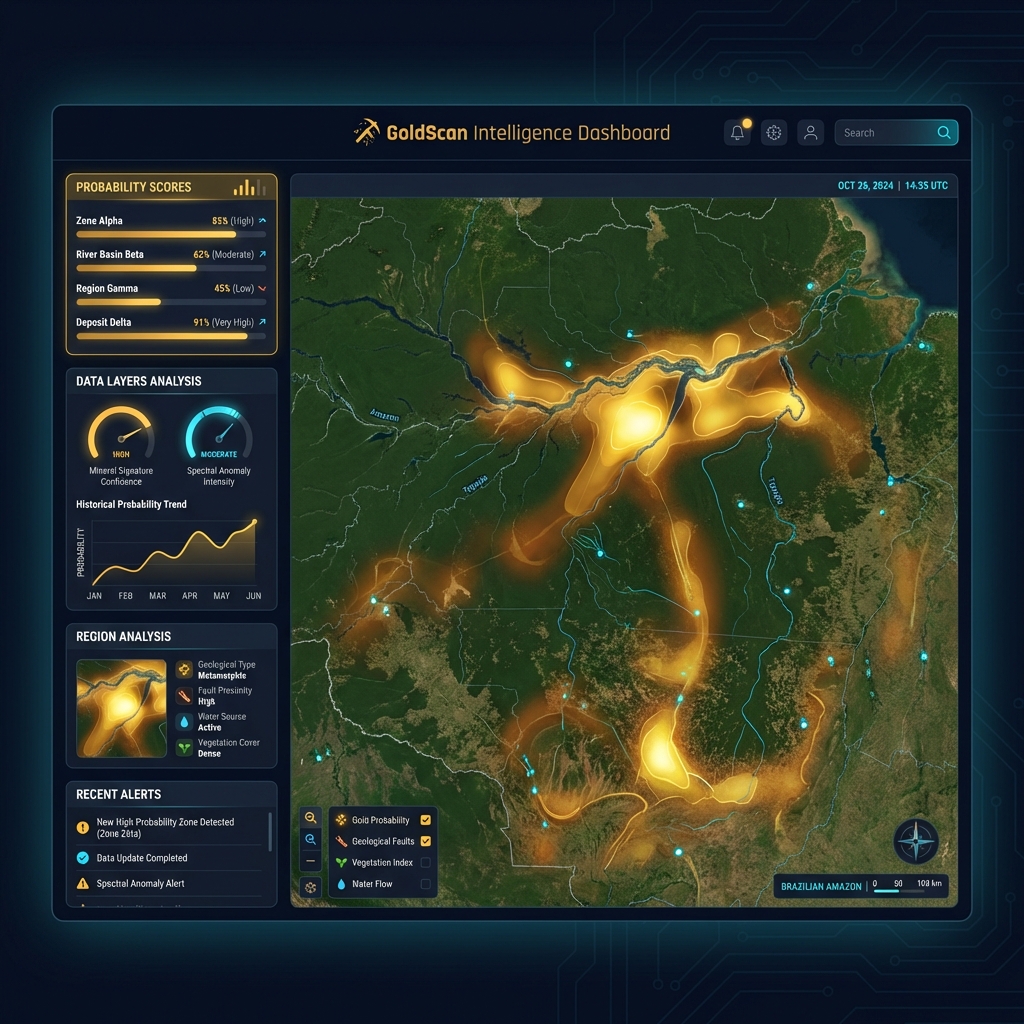
Mineral Intelligence From Space

GoldScan™ combines satellite intelligence, autonomous drones, and AI probability modeling to deliver drill-ready mineral intelligence starting at $75,000 USD — 75% cheaper than helicopter surveys.

10 Minerals
6 Claims
26.8K Hectares
28 S2 Observations

10 Mineral Profiles.
One Platform.

Each profile includes tuned spectral indices, probability weights, geological indicators, and AI-optimized demo values. Switch minerals — the entire analysis pipeline adapts instantly.

🥇
Gold
Au
6 spectral indices
☢️
Thorium
Th
5 spectral indices
🔶
Copper
Cu
5 spectral indices
⛏️
Iron Ore
Fe
5 spectral indices
🔋
Lithium
Li
5 spectral indices
🪨
Tin
Sn
5 spectral indices
💎
Diamond
C
5 spectral indices
🧲
Rare Earth
REE
5 spectral indices
🔩
Manganese
Mn
5 spectral indices
🔗
Nickel
Ni
5 spectral indices

Satellite → AI → Drone

Three phases to go from zero to drill-ready intelligence

🛰️

Satellite Intelligence

Ingest free Sentinel-2, Landsat, ASTER, and SRTM data via Google Earth Engine. Compute spectral mineral indices tuned for your target mineral across up to 25,000 ha.

2 weeks · from $75,000
🧠

Deep Intelligence + AI

ANM SIGMINE regulatory feed, production data, cross-validated spectral fusion (Sentinel-2 × Landsat × ASTER), drill targets with confidence scores, and investor-ready reports.

4 weeks · from $250,000
🚁

Ground Truth + E2E Ops

Deploy 7-sensor autonomous drone fleet (magnetometer, hyperspectral, LiDAR, gamma-ray) with satellite uplink. Ground truth at 5cm. Full operational deployment available.

8-12 weeks · from $500,000

Live Intelligence Features

GoldScan isn't just analysis — it's a real-time intelligence platform powered by GCP, with cooperative claim integration, temporal analysis, and investor-ready exports.

⚖️
Cooperative Integration

6 claims across 2 holders — Cleto (1,355 ha) + 4 Cooperative claims (25,444 ha). Color-coded map with click-to-zoom comparison table.

CLETO COOPERATIVE
📡
Spectral Time-Series

28 Sentinel-2 observations (2020–2026) tracking 4 spectral indices: Iron Oxide, Clay/Sericite, Silica, NDVI — with trend analysis.

4 indices · 7 years
📄
PDF Report Export

One-click export to investor-ready PDF. Print-optimized A4 layout with metadata footer (GCP project, mineral, timestamp, data sources).

NI 43-101 READY
☁️
GCP Cloud Native

BigQuery data warehouse (4 tables), Cloud Storage uploads, Cloud Run deployment, REST API with 8 endpoints.

BigQuery Cloud Storage Cloud Run

8× Faster. 75% Cheaper.

GoldScan replaces months of fieldwork and $3,600/hr helicopter surveys with autonomous drone intelligence at $900/hr

Traditional Exploration
$400K+
12-24 months
  • $3,600/hr helicopter surveys
  • Limited to one mineral at a time
  • No AI probability modeling
  • No regulatory intelligence
  • Results in months
  • No satellite integration
VS
GoldScan™ by Numbird
From $75K
2-12 weeks
  • $900/hr drone (75% savings)
  • 10 minerals simultaneously
  • 22 data sources fused with AI
  • ANM SIGMINE regulatory feed
  • Results in 2 weeks (sat phase)
  • Sovereign cloud option (LGPD)

Investment Tiers

From satellite-only intelligence to full E2E operational deployment. All prices USD.

Satellite Recon
$75K
R$375K · per site · 2 weeks
  • 🛰️ 5 satellites · AI scoring
  • 📊 10 mineral profiles
  • 📈 Time-series 2020-2026
  • 📄 Executive report
$3/ha · up to 25K ha
RECOMMENDED Deep Intelligence
$250K
R$1.25M · per site · 4 weeks
  • ✅ All Satellite Recon +
  • 📡 ANM SIGMINE + CFEM
  • 🎯 10 drill targets scored
  • 📋 Investor report (50+ pg)
  • 🔑 BigQuery API access
$8.33/ha · 30K ha
Ground Truth Survey
$500K
R$2.5M · per site · 8-12 wks
  • ✅ All Deep Intelligence +
  • 🚁 7-sensor drone (2 aircraft)
  • ☢️ Gamma + Mag + LiDAR
  • 🌈 Hyperspectral 5cm
  • 📐 3D model + Vertex AI
$900/hr · 200 hrs included
Full E2E Ops
$1M
R$5M · 6-month contract
  • ✅ Complete E2E solution
  • 🏢 Sovereign cloud + teams
  • 🔗 Sat-drone Ka-Band link
  • ⚡ 20-min SLA airborne
  • 📡 260 hrs + 23K ha map
$7/ha · $900/hr · $60K/mo

Drone: $900/hr vs helicopter $3,600/hr · 75% savings · Cap-and-Trade model available

📧 Request a Quote

8 Free Data Sources

All satellite and geological databases cost $0. You only pay for compute and analysis time.

🛰️
Sentinel-2 SR
10-20m · ESA / Copernicus
Free
🌍
Landsat 8/9
30m · NASA / USGS
Free
🔭
ASTER
VNIR/SWIR/TIR · NASA
Free
⛰️
SRTM DEM
30m · USGS / JAXA
Free
🗺️
CPRM GeoSGB
Brazilian Geological Survey
Free
🌳
MapBiomas Mining
AI-classified since 1985
Free
🌿
PRODES/DETER
INPE Deforestation
Free
📋
ANM Production
National Mining Agency
Free

Ready to Get Started?

Contact our team for a personalized demo of the GoldScan™ Intelligence Platform. See how satellite + drone intelligence can accelerate your mineral exploration.